Cucumber Falls (Ohiopyle State Park)

Who doesn’t love a beautiful waterfall?! That is why we are sharing Cucumber Falls even though we don’t have an exact trail mapped out. Although I didn’t get any pictures, Cucumber Falls is actually GREAT for bouldering. The waterfall is surrounded by rocks. It’s a fun climb, but be careful because some of the rocks are wet and slippy.

cukeredo


When you head down into the trail from the parking lot, you will go towards the right. It leads you down a bunch of steps. We went all the way down the steps and bouldered our way up to the waterfall. Then, we went behind the waterfall and out the other side. There are some seriously awesome views! I *wish* we had more pictures, but I guess you’ll just have to go see it for yourself … (; I did have my Fitbit map going, and it said we went about 1 mile between walking to/from the trail and bouldering. Not too shabby, right?

Parking: The lot is very easily visible from the road.

Bathrooms: none

Water: none available for drinking

Special notes: I would recommend wearing tennies or water shoes – something with some grip so you don’t fall!

Also … I think the Meadow Run Trail connects the Waterslides and Cucumber Falls. I did see a trail when we were heading to the falls, but I don’t remember one by the waterslides. If you happen to try it, let us know!

cukefall3

CukeFall1

cukefall2

It’s kind of like our own little piece of tropical paradise right here in SWPA!

Have fun,

Amy + Dominique

Natural Waterslides (Ohiopyle State Park)

Okay, so … this isn’t a trail, but it IS a lot of FUN if you like water! Have you ever done natural waterslides anywhere? One summer when I was working as a camp counselor, we would take our campers to Linn Run State Park to the natural waterslides there, but these ones might be even better! In previous years, there wasn’t much water in them but this year is a different story! Look at all that water! A bunch of teens were having a blast sliding all the way down to the end because of the currents. Be careful, though! Rocks are hard.

WaterslidesTitle

Parking: The waterslides have their own parking lot! Just walk down the wooden steps and you are there!

Bathrooms: none

Water: none for drinking

Special notes: Water shoes are probably a good idea! You’ll also want to bring a towel.

Waterslides1

Waterslides2

Waterslides3

If you’re in the Ohiopyle area, we hope you stop by to at least check them out and get your feet wet!

Happy Watersliding!

Amy + Dominique

Ferncliff Trail (Ohiopyle State Park)

Today we are taking you south of the city to the beautiful Ohiopyle! This is such a fun place for a day/weekend getaway. You can hike, camp, go whitewater rafting … there really is so much possibility! We’ve even grabbed lunch and dinner a few times in Ohiopyle – lots of great food choices or you can picnic. Though, no trip is complete without stopping by the Natural Waterslides and Cucumber Falls to chill off.

Winding along the side of the river and up into the woods, the Ferncliff Trail is definitely fun. It’s more of a hiking trail than a running trail due to the terrain. Below is a video to get you onto the trail and help make navigating it easier:


Annnnd here is another map doodled on by yours truly in hopes helping you find your way. I don’t know if the trails are mapped 100% correctly on the map. We got confused near the end so I included a picture of the steps that you will go up near the end so you know what to look for. I think there might be some overlapping of man made and deer made trails.

FerncliffTrailMap


Distance: ~3 miles

Estimated time: It took us 1 1/2-2 hours walking, but that’s because there are so many photo ops!

Parking: You can enter 7 Sheridan St, Ohiopyle, PA into your GPS. This is the address for the Laurel Highlands Information Center because there isn’t a specific one for the parking lot. The parking lot is on the left immediately after the information center. It’s very easy to see.

Bathrooms: Restrooms are in the information center, and they were CLEAN!

Water: You can get water in the information center and at any of the shops along Main Street and the connecting side streets. No water is available along the trail.

Special notes: Wear sunscreen, beware of poison ivy (stay on the trail!), take a camera, and if it has rained recently, be prepared for a few muddy spots.

We hope you enjoy this little getaway trail. If you have time, look at Christian Klay Winery and stop in for some Lavender Mist wine!

Cheers,

Amy + Dominique


Nine Mile Run -> Mon River (Frick Park)

Running loop trails is fun, but running to a beautiful destination can make a run/walk that much more exciting! After the last (slightly complicated) trail loop, we decided on something a little bit more simple but still beautiful! This route will take you through Frick Park down to the Monongahela River, which actually leads to an entrance of the Steel Valley Heritage Trail on the opposite side of the river from the Waterfront.

As always, here is a quick video guiding you to the start of the trail and some if its twists and turns:


And here is your map we doodled the trail on, but remember, if you have GPS on your phone, you can always pull up Google Maps and see exactly where you are on the trail. I always find that super helpful so I know where I am and how far I have to go if I’m trying a new trail.

ninemilerunmonrivermap


Distance: ~3.5 miles

Estimated time: 35 mins (jog)/ 70-80 mins (walk) – add extra time to catch a breather by the river

Parking: We recommend starting this trail from the parking lot off Hutchinson Avenue in Regent Square. You drive down a windy road to the parking lot. There are plenty of spaces, and overall, it is easy to find and navigate! Here is a map to the parking lot:


Bathrooms: There is a port-a-potty in the parking lot.

Water: There is no water available along the trail, but if you forget water or snacks, there are a few mini-marts/shops in Regent Square that should have something!

Special notes: You do cross the street in this trail so be careful! Wear sunscreen, some parts don’t have much shade. Also, if you choose to take the lower path on the way back and its overgrown a bit, use your noggin and check yourself for ticks at the end.

We hope you enjoy this route as much as we do. Keep posted for a FUN variation to this route over the summer! Let’s just say it will involve … PANCAKES!

Cheers,

Amy + Dominique

Point State Park -> North Shore Loop (Point State Park)

The Point and the rivers in Pittsburgh really are beautiful. That is what makes us LOVE Point State Park even though parking can be a pain sometimes. The park in terms of trails is not very large, so this one might seem a little confusing with all the turns, but I can assure you it’s really not hard. Let me break it down for you:

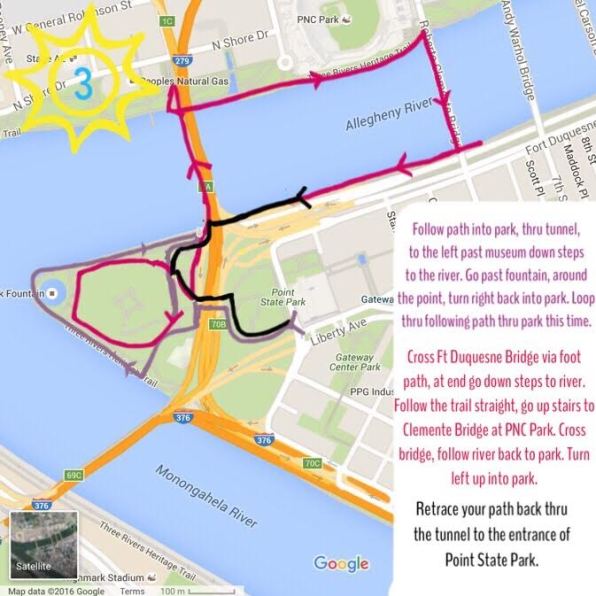
During this run, you will make two loops around Point State Park. The first loop is around the outer edge along the river. Then, the second loop is through the middle of the park. For the second loop, you are going to take the trail that you passed at the beginning. It will be on the right before you get to the steps leading down to the river (after you pass the museum). The two trails (outer and inner) run parallel more or less.

After you complete the second loop (the inner loop), you are going to follow the ramp up to the bridge. The ramp is located to the right when you come out of the tunnel with the reflection pools at the start. It’s not a large park, so even if you miss a turn, another little path should lead you to pretty much the same area.

Then you cross the Fort Duquesne Bridge, run along the Allegheny River past PNC Park, walk up the steps to PNC Park at the Clemente Bridge and cross the Clemente Bridge. At the end of the Clemente Bridge, you take the steps back down to the river and follow the trail up the other side back to Point State Park. If you miss your turn back into the park, you’ll just end up at the fountain again, which is actually a nice place to stop and rest!

Here is a (kind of lengthy) video of the twists and turns! Below that is the map. Just like the other parks, if you have GPS on your phone, you can pull it up to see where you are on the trail! We took a screen shot of Google Maps and drew on the trails.


PointStateParkNorthShoreLoopMap


Distance: ~3.1 miles from the entrance of the park

Estimated time: 35 mins (jog)/ 60-75 mins (walk)

Parking: Street parking is free on Sundays. You can park along the Boulevard of the Allies or on Liberty across from the park. Saturday and Sunday, parking is $5 in city garages (not all garages are Pittsburgh Parking Authority garages, though, so be careful). Weekdays, you can park for free along East Carson in the South Side, cross the Smithfield Street Bridge, and walk over to the Point. You can also take the Trolley in from the North Shore for free (I think still, right?), just get off at Gateway Center. You can also take any other T in and get off at Gateway Center. Parking on the North Shore and walking in is another option.

Below I’ve highlighted where there is some free street parking on Sundays and holidays.

PointStateParkParking

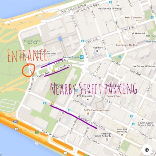
Here is a map leading to the entrance of Point State Park:


Bathrooms: There are bathrooms near the fountain.

Water: You will find water fountains seasonally by the the bathrooms near the fountain, and the Cafe at the Point sells beverages and snacks.

Special Notes: There are steps in this trail. At the end of the Fort Duquesne Bridge, there is a ramp for bicycles. I am not sure if there are ramps on/off the other one. Kayaks are available for rent by PNC Park along the river, and you will find lots of benches in Point State Park.

This trail is a fun little city excursion. Be sure to check to see if there are any events going on at the Point, too! And, it is a must to stick your feet in the fountain when no one is looking. 🙂

Have a GREAT run!

Amy + Dominique